
And now for something completely different…
The world of politics, diplomacy, refugees, and climate change isn’t going away.
But, once in a while, a vacation is helpful.
This is going to be the start of what I hope to become a (semi) regular series… I want to talk about hiking and climbing. In particular, I want to actually hike a trail and/or climb a mountain, and then talk about it here. These pieces won’t necessarily be trip reports in the same vein as what you might find on http://www.oregonhikers.org/ or https://www.summitpost.org/. But they will be my personal thoughts on the experience of these trails.
Last October, I moved to Portland, Oregon from Kansas City, Missouri. The move was for work, but I’ve always loved the Pacific Northwest, and always hoped to end up here. In particular, I loved the mountains and the hiking. This is – for my money – possibly the most beautiful part of the United States. And since hiking and climbing are already among my favorite activities (apart from online rabble-rousing), I was excited for the chance to spend time wandering around this area. So, I decided to give myself a birthday present. I took the day off work, and set out along the Columbia River for my first serious Northwest hike in about a decade.
I knew I wanted elevation, but I also knew I’m in mediocre shape – and now closer to 40 than 30. It would be wise to build myself up before trying to tackle something serious. So, after some research, I came up with Dog Mountain, in the Columbia Gorge, on the Washington side. Fairly steep and strenuous, but not particularly high, long, or dangerous. The vistas look lovely, and every trip report seemed to be enthusiastic. If Dog Mountain proved to be something I could handle, then perhaps in a couple weeks, I would look across the Gorge at Mt. Defiance – a hike nearly twice as long and twice as high.
So, emboldened by this research, just this past Friday morning, I set out from my home in Portland, and headed east down the river. Dog Mountain is just past the town of Stevenson – about an hour from downtown Portland. The trailhead is a wide gravel parking lot right off of Highway 14. It tends to get busy on the weekends, so I made sure to be there on a weekday, relatively early. At the time I arrived, there were only a couple other cars in the lot.
An information/pay station stands near the start of the trail, as well as this sign:

Hunter Breckenridge – 2018
3.8 miles to the top? Piece of cake.
Mmmm… cake. Dammit, now I’m hungry.
Okay, where was I? Right… time to start walking.
At this point, it was about 8:15. I originally wanted to show up earlier, but a warm bed slowed me down just a bit that morning.
Speaking of walking, I have to emphasize that a good pair of hiking shoes is invaluable. Maybe something with some ankle support. You’ll appreciate that – especially on the way back down.
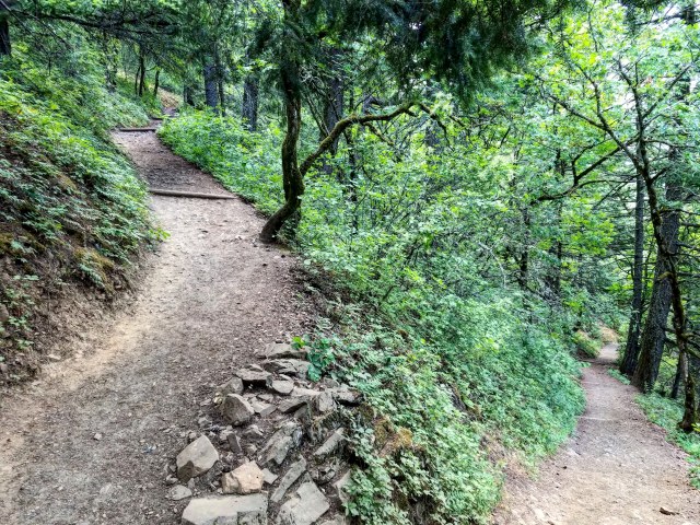
The trail gets steep right from the get-go. It starts off wide and is initially mostly gravel, but gradually turns into dirt – albeit with a healthy amount of fist-sized rocks scattered along the way.
There’s a pair of restrooms (compost toilets, no sinks) just a few hundred feet from the start, but then after that, it’s just you, the trail, and the woods. And possibly many other hikers, though at just past 8 AM on a Friday, the trail was mostly empty.

Hunter Breckenridge – 2018
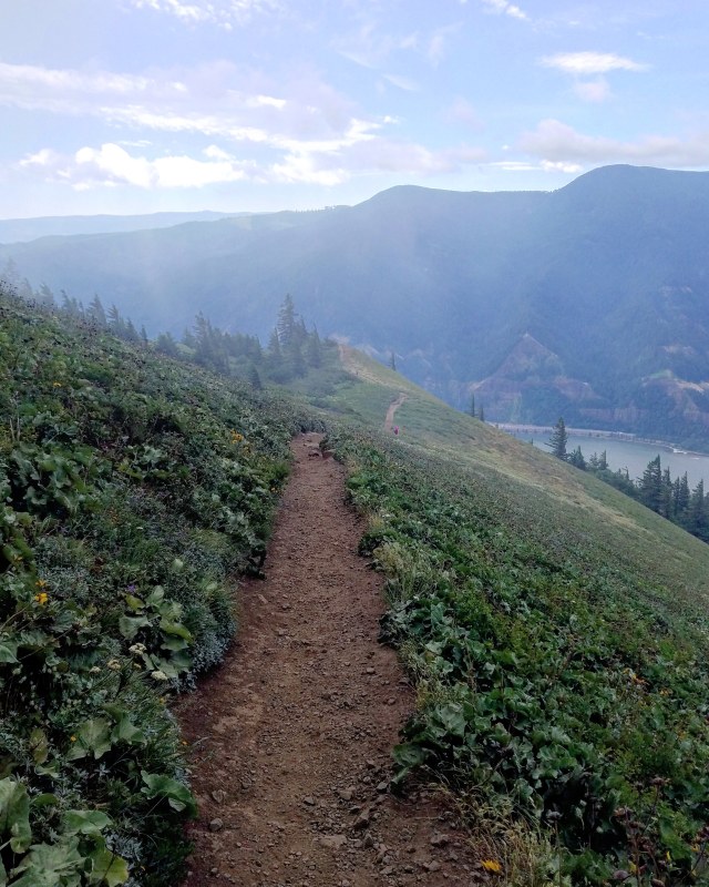
The trail inclines steeply, with plenty of tight switchbacks through the woods. Now and then, a gap will appear, providing lovely (but still low) views of the Columbia Gorge.

Hunter Breckenridge – 2018
And now and then, obstacles – usually trees – dot the path.

Hunter Breckenridge – 2018
You’re going to take this path for the first 0.7 miles. And I will admit, after scoffing at “only” 3.8 miles at the start, I quickly gained respect for that whole gravity thing. Walking 0.7 miles on level ground with a smooth surface is pretty easy. Doing it uphill on dirt and rocks is… well, less easy, especially if you don’t pace yourself. Despite the 55 degree Fahrenheit temperatures, my hoodie came off pretty quickly. Stylishly wrapped by the arms around my waist, of course. I felt kind of silly even bringing it, as I was quickly dripping with sweat. And now I looked like a scruffy imitation of an 80’s preppy teen bully.
Look – a switchback! Hunter Breckenridge – 2018
As one heads up the trail, it’s highly recommended to stay on the trail. Poison oak abounds, and an attempted shortcut between switchbacks might end up being rather… uncomfortable.

Hunter Breckenridge – 2018
But the vegetation is lovely, even from the trail. And animal life is plentiful, although they make themselves heard more than seen, as birds chirp overhead, and the branches shake with squirrel gladiatorial games being waged in the canopy.
Well, that’s the mental image I had. Maybe hiking alone was a bad idea.
But I digress.
Meanwhile, after those 0.7 miles that feel just a teensy bit longer – you come to a junction. This is the “difficult” path versus the “more difficult” path. Every guide I’ve read tells me there isn’t actually a huge difference in difficulty between the two paths – but the merely “difficult” path to the right (a newer and shinier one, I might add), is vastly more scenic, running along the edge of the mountain closer to the Gorge.

Decisions… Hunter Breckenridge – 2018
I’m more than willing to take the advice of people who’ve already been there – and I did kind of show up for the vistas. So, about 25 minutes into the hike, I took the path to the right, and plunged into the woods.
I noticed the wind was picking up a bit, but I was still warm enough to justify the hoodie remaining firmly around my waist. But my now sweaty legs were objecting to my choice of wearing jeans, instead of something lighter and looser.
As I pushed forward – and up (mostly up), I found myself in a wide forest, where the path was mostly straight, and the forest was filled with evenly spaced, mostly bare trunks. The effect was surprisingly spooky, but also quite serene. At this point, I had only encountered one other pair of hikers on the path, and they were on their way down. I had the mountain to myself, and it was exactly what I was hoping for.

More switchbacks! Hunter Breckenridge – 2018

Hunter Breckenridge – 2018

Hunter Breckenridge – 2018

Look up! Hunter Breckenridge – 2018

Hunter Breckenridge – 2018
Oh yeah, and there was also the spooky hut. It showed no sign of recent occupation, although my expertise in these matters is limited. Also, my urge to suddenly re-enact Scooby Doo was powerful at that point. I let out one Zoinks!, and moved on.
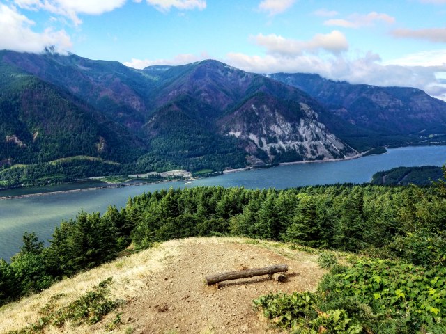
Finally, 1.2 miles past the juncture – and about an hour into the hike – I came out of the forest to a clearing – the lower lookout. There were views of the Gorge in both directions, and it was absolutely stunning. It was also fairly windy up here. The hoodie ended up coming back on.

Hunter Breckenridge – 2018
Hunter Breckenridge – 2018
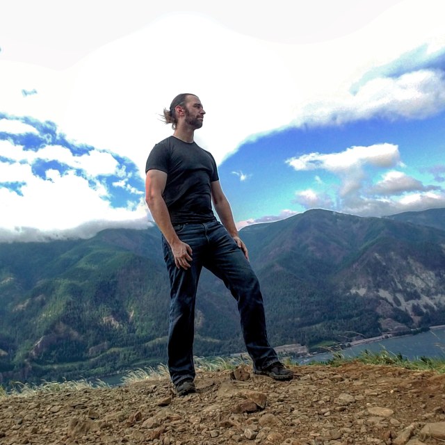
It’s me, being stoic. Or, maybe just silly. Hunter Breckenridge – 2018
After some time enjoying the view, I headed back up the trail, back into the forest.
The trail was noticeably steeper at this point, and the bare lower branches of the trees at this point were covered in moss. They looked kind of like broken green ladders.

Hunter Breckenridge – 2018

Hunter Breckenridge – 2018
At 9:30, I reached the point where the “More Difficult” trail met up with my bunny slope. A sign very kindly informed me of my progress:

Hunter Breckenridge – 2018
The sky had darkened at this point, and a mist had started to fall. I’m not sure what the difference is between fog and a cloud, but I was in a light version of one of them.

Hunter Breckenridge – 2018

Hunter Breckenridge – 2018
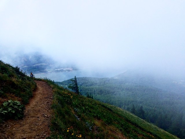
At around 9:50, I finally caught a glimpse of the summit meadow, just above me. The trees were now mostly behind (and below), and the trail was more exposed. Also, the cloud/fog/poison mist was pretty heavy, and I couldn’t see the gorge, or even much of the mountain below – which was admittedly disappointing. I was hoping the covering would be on its way before I reached the summit. I did get a brief glimpse of the gorge below through a fleeting gap in the clouds, and it felt like a bit of a tease.

Hunter Breckenridge – 2018
The wind was also picking up strength. I rounded a bend to the left, and there was the old fire lookout point, also known as Puppy Dog Lookout. It was just about 10 AM. At this point, the view was still pretty minimal, but I could tell I was up high (2525 ft), and quite exposed. It appeared that the final push to the peak was starting here. So, I rounded the bend, and trudged into the wind and mist through the meadow.

Hunter Breckenridge – 2018

Hunter Breckenridge – 2018
The next sign on the trail was not all that useful.

Hunter Breckenridge – 2018
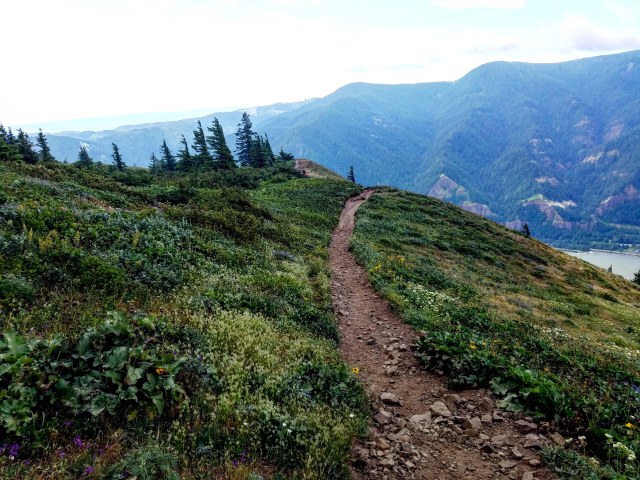
The meadow became steeper on both sides, until it turned into a ridge, complete with some rocky outcroppings. The steepness of the path, the limited visibility, and the high winds, all combined to create a disorienting effect. I had to slow down. I can’t say I felt like I was in danger, but the conditions were harsher than I had anticipated.
Finally, as the trail narrowed, it switched back one more time, and then up to the top of the summit meadow. There were some wildflowers left, but not like some of the photos I’ve seen from late May and early June.

Hunter Breckenridge – 2018
The path itself started to level, no longer heading steeply up. This was a bit of a relief.
The wind, however, was stronger than ever. I’m not a great judge of guessing windspeed, but a very rough estimate of 30-40 mph seems about right. Gusts maybe closer to 50. The grass and the flowers were dancing with some enthusiasm. A few hundred feet past the last turn, there was a spur up and to the left, that went hundred feet or so. It ended up in a dirt covered clearing, with a small ring of trees at the top. This was the summit. Further behind the summit were much larger trees, towering over me. I recognized that they started behind the ridge, much lower, but it was a strange effect, to be at the top of a mountain, looking up at treetops.

Hunter Breckenridge – 2018
Anyway.
I lingered for a few minutes, but the view wasn’t improving, and a couple pairs of hikers were appearing on the summit with me. I headed back down the spur to the main path. I had the option of returning the way I came, or heading forward down the path.

The summit grove. Hunter Breckenridge – 2018
According to the maps and guides, this would take me back to the fire lookout through more forest.

Hunter Breckenridge – 2018
I figured I should see as much as possible – and maybe the forest would help block some of the wind.
It was only a few hundred feet from the summit spur to the start of the forest, but I quickly discovered that this was much denser and heavier than the woods on the lower part of the mountain. The rain had made the leaves wet, and the ground mushy. At points, the vegetation was so heavy that I couldn’t see where my feet were stepping – which is not a good thing when walking down an unknown (to me) trail 2900 feet above the ground below. I didn’t last long. Pushing through the brush, stepping off the trail repeatedly, and having to duck beneath branches that would make Danny DeVito do the limbo was more than I felt like dealing with. At least the path back had the potential to be scenic – and more importantly – I could see where I was going. So I turned back. I found myself back on the summit meadow. I even ran back up the spur to the summit itself, hoping that maybe, just maybe, the clouds would start to clear. But… not yet.
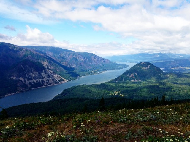
At about 10:35, I decided to start heading back. Back down the meadow, back to the switchback and the ridge on the west side of the summit slope. Then, as I glanced to my right, I could start to see a shimmer through the clouds. It was clearing up! And I could began to see this great view everyone raved about.
Hunter Breckenridge – 2018

Hunter Breckenridge – 2018
Hunter Breckenridge – 2018
I followed the path down the ridge, heading back to the fire lookout. More people were now popping up on the trail. I was grateful I started out when I did, so I was able to enjoy the first half in solitude.
Hunter Breckenridge – 2018
Hunter Breckenridge – 2018
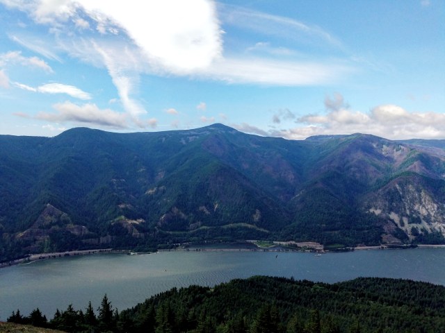
The winds were still strong, but they were blowing the clouds away, so that was something. Just before 11, I made it back to the lookout. And by then, the clouds had largely cleared. Just in time.
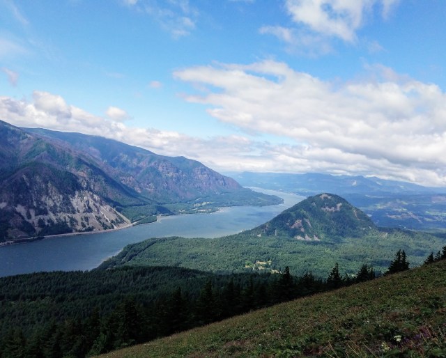
Yeah, a written description couldn’t do it justice. The photos really don’t, either, but it’s closer. Please enjoy these, and consider taking a trip to Dog Mountain, yourself:

Hunter Breckenridge – 2018
Hunter Breckenridge – 2018
Hunter Breckenridge – 2018
Below is me again, pointing at my next target – Mt. Defiance. If the image were better, you could get a better view of the peak of Mt. Hood just poking over the ridge.

Hunter Breckenridge – 2018
After a few minutes of photos and gawking, I turned back down the way I came.

Hunter Breckenridge – 2018

Hunter Breckenridge – 2018

Hunter Breckenridge – 2018

Hunter Breckenridge – 2018
No longer fighting gravity, the path was quicker… but I also failed to tie the top part of my hiking shoes, and I kept rolling my ankles on the rocks in the trail. Part of the problem was me being clumsy, and part of it was my rubber ankles… Still, to the poor souls slogging through this, make sure you have good hiking shoes, and make sure you have ’em laced up all the way. Because ouch. My ankles are still sore, two plus days later.
But I kept staggering downhill, now muttering hello to hikers coming up the other way every few minutes. Definitely glad I started early.
Funny thing was, despite my general disinterest in interacting with strange people, I was pleasantly surprised to note that there was a sense of camaraderie among my fellow hikers. People asked me how the hike was, if there were flowers on the upper meadows, even just how I was doing. It was all pretty normal stuff – but for me, it was a good feeling. I stopped to chat briefly with a couple groups as I made my way down, and I didn’t hate it. And that seriously is a big deal for me.
Just about 4 hours after starting, with aching ankles, I clambered down to the trailhead.
I’m not an expert hiker. I’m not all that experienced. But I’m now living in an excellent area to become more experienced. If things go well, I’m going to do this again in a couple weeks. Dog Mountain got me hooked. It was long and intense enough to feel like I made a real effort, but it also wasn’t so grueling that I couldn’t handle it. The views were stunning and the environment was just lovely in general. And even the people I encountered were universally friendly.
This was a good day, and I hope to share more of them in the future.

Glad you started your year with a mountain hike, as you’d dreamed of doing this summer. Lovely photos. Definitely can attest to the friendliness of the people of the Pacific Northwest.
Looks like a lovely hike!
Pingback: Hiking Report – Mount Defiance | A Skewed Perspective
Pingback: Hiking Report – Saddle Mountain | A Skewed Perspective
Pingback: Hiking Report – Battle Ax Mountain | A Skewed Perspective